With a renewed enthusiasm for photography and local history, I set out this blog as a record of my experiences with images and narratives. It is my hope that you find something of interest on this site. Please feel free to contact me for more information on any of the posts. You can see a comprehensive list of my blogs at my website :- http://www.davidnurse.co.uk

Alison Lapper MBE


The marble statue of 
Alison Lapper MBE
 by Marc Quinn.

Date of Visit August 2007


The marble statue of  Alison Lapper MBE  by Marc Quinn.
Click image for larger view


The fourth plinth is the northwest plinth in Trafalgar Square in central London.
It was originally intended to hold an equestrian statue of William IV however, due to a lack of funds this was never completed. For over 100 years the plinth remained bare until in 1998 three contemporary sculptures were displayed temporarily on the plinth.
Soon afterwards Sir John Mortimer was asked to suggest how this plinth should be used and his report recommended that the commissions remain a rolling programme of temporary artworks rather than settle permanently on one figure or idea to commemorate.


Following this, the first of the works of art was this statue in 2005.


This 3.6 metres (12 ft), 13-tonne torso-bust of Alison Lapper explores representations of beauty and the human form in public space It was displayed here from the15th of September 2005 until late 2007 and was remade on an even larger scale for the closing ceremony of the London 2012 Summer Paralympic Games.


Alison Lapper was born on 7 April 1965 in Burton upon Trent, Staffordshire. She was born without arms and with shortened legs, a condition called phocomelia.
When she was fitted with artificial limbs, she felt that their aim was not to help her but to make her look less disconcerting to others. She abandoned them, finding life far easier without external aids.


Alison is an accomplished artist and is a member of the Association of Mouth and Foot Painting Artists of the World (AMFPA),


In May 2003, Alison was awarded an MBE for services to art. In July 2014, she was awarded an honorary doctorate from the University of Brighton.


I took this photograph on a visit to London from the top of an open-topped London tour bus in 2007. It was just an opportunity that occurred and I took many shots but this came out best.


Footer:Visit Information: -

Google Reference: -
51.508197871534826, -0.12871047896740126

Google search term:
Trafalgar square

What Three Words reference: -
///farms.activism.panic

OS Details: -
OS Grid Ref: TQ 29961 80465 Altitude:34 ft


A full list of blogs can be found at my website


Read More

Ynyscedwyn Ironworks


The site of the Ynyscedwyn Ironworks is a remnant 
of the past and is one of the most iconic sights
in the village of Ystradgynlais near Swansea.


Visit Date March 2023


Ynyscedwyn Ironworks
Click on the any image for a larger view


Ynyscedwyn Ironworks' long history has been traced. Thanks to a find of pig iron it has been able to date iron production here back to 1612.

As you would expect the site has gone through many changes over the centuries.


Ynyscedwyn Ironworks


What we see today is dated from a stone in the base of the wall of the chimney dated 1872 and is what is left of a mill that was constructed then possibly for Steel production. This was never completed and the site shortly after this housed a tinplate works.


Ynyscedwyn Ironworks
Click on the any image for a larger view


By 1837 three blast furnaces were running at the site which increased to 6 by 1853.

by 1854 the Inyscedwyn Ironworks were the largest producer in the country.

However, the glory days of the works were soon in decline after this date and by 1869-70 the works were closed.


Ynyscedwyn Ironworks
Click on the any image for a larger view


It was then that the rolling mill project was started, the remains of which we see today. But they were never completed and work was started converting the site to a tin works.

The tin works consisted of three operating mills from the periods 1889-1903 and 1905-41 before they also went the way of the ironworks.


Ynyscedwyn Ironworks


The site then lay in disrepair until the site was cleared and landscaped in the late 20th century only leaving what we see today primarily the 1872 chimney and the massive arches on either side.


Ynyscedwyn Ironworks
Click on the any image for a larger view


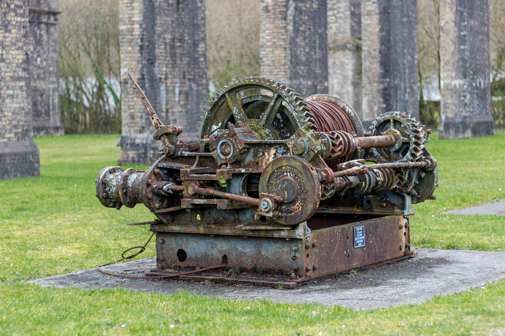
Also on the site, a few pieces of the works are left. A dram or coal cart, the remains of a winding mechanism and the remains of a miner's cage.


Ynyscedwyn Ironworks
Click on the any image for a larger view


The site of the ironworks is open to the public and a housing estate is close by and also a children's playground is now alongside the historical site.


Footer:Visit Information: -

Google Reference: -
51.7682972861281, -3.7642929522232205

Google search term:
Ynyscedwyn Iron Works

What Three Words reference: -
///glassware.clips.demanding

OS Details: -
SN 78346 09208 : Altitude:230 ft

Additional information.

Visiting is very easy.
From the M4 junction 45 take the A4067 north then the B4559 the site is Situated on grassed site bounded by Glan-Rhyd Road and Pont Aur, just N of Ystradgynlais Hospital.
There is a parking at the site. (51.76851605993839, -3.7649497331170707).


A full list of blogs can be found at my website

Read More

TÅ· Newydd Burial Chamber.


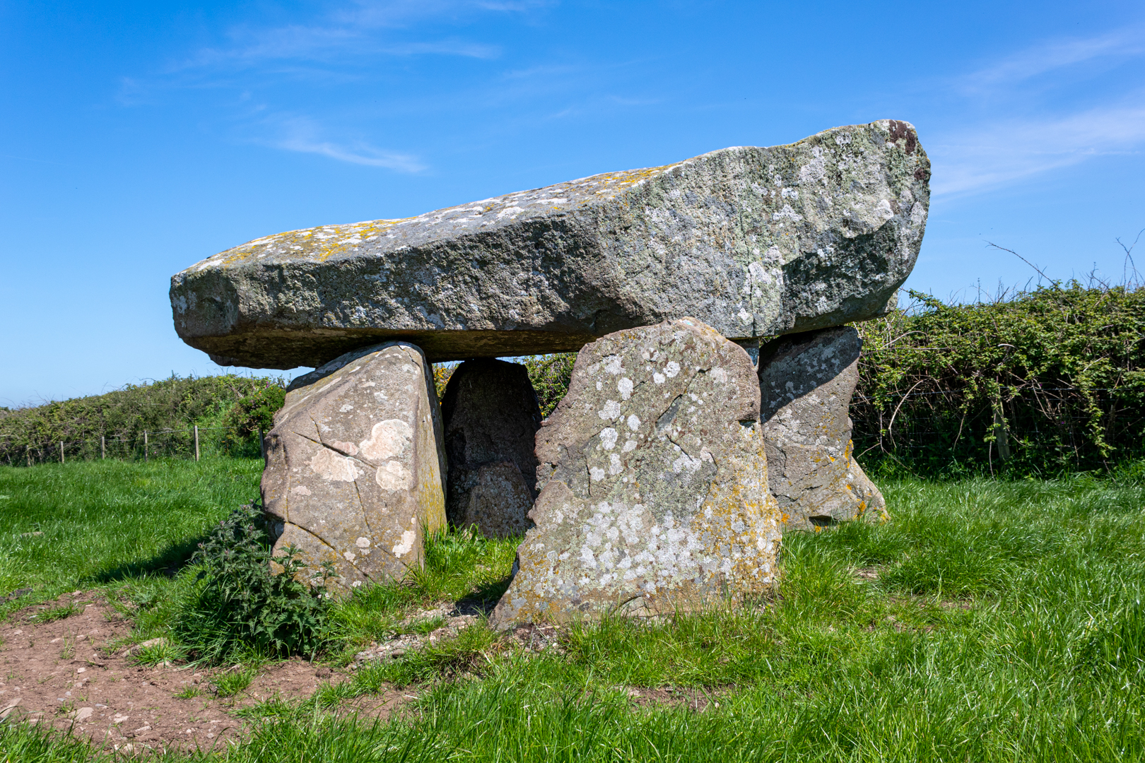
TÅ· Newydd burial chamber although ruined, is still a good example of a megalithic dolmen. 
Set on a natural outcrop it would originally have been covered with a mound or cairn 
now marked out by the small bollards that surround it.


Visit Date May 2023


Ty Newydd Burial Chamber (Dolmen)
Click on image for a larger version.


Ty-Newydd has a massive cracked capstone, about 4.0m by 1.8m and up to 1.2m thick, that rests on three of the four remaining uprights. The Capstone is likely to have originally been wider as part of the southern edge has broken off.


Ty Newydd Burial Chamber (Dolmen)


The chamber was originally part of a passage grave. One theory is that the tomb was originally similar to Bryn Celli Ddu (the subject of a later blog), with a second chamber joined to the first by a passage, and the entire tomb was covered by a large earth mound which was later removed.


Ty Newydd Burial Chamber (Dolmen)


Early reports claim that the second larger chamber existed close by, this has long since been broken up and carried away as has any surface evidence of a covering stone cairn so it is impossible to establish the original layout of the site although several small concrete markers around the chamber hint at the possible extent.
It is said to have once been enclosed by a circular wall about 32m in diameter and this may reflect the form of the cairn.


Ty Newydd Burial Chamber (Dolmen)


The huge tilted capstone is split and is now partly supported by brickwork and concrete. This does distract from the natural beauty of this site however one suspects that without this intervention the capstone would now be on the ground.
There is a photo in 'The Ancient Stones of Wales' by Barber and Williams, which purports to show Ty Newydd in 1900, with the capstone resting on 3 uprights, without all the modern brickwork.


Ty Newydd Burial Chamber (Dolmen)


The chamber was excavated in August 1935 by Charles Phillips.
There was a lot of charcoal, suggesting evidence of a large fire that formed this thick layer of charcoal as well as a quantity of quartz.


Ty Newydd Burial Chamber (Dolmen)


There were no human remains found at the site however the finds included five flint flakes, a burnt flint arrowhead, a small chip from a polished flint axe, and some small fragments of pottery. Phillips believed that the pottery fragments were from the Beaker culture, suggesting a Bronze Age reuse of this earlier Neolithic monument.


More recently, prehistoric artwork termed ‘cup marks’ have been detected on the capstone.


Footer:Visit Information: -

Google Reference: -
53.23592779682485, -4.482380635799995

Google search term:
I have had a few problems with google maps trying to locate the exact place by description so please use the google reference above.

What Three Words reference: -
///overgrown.broke.slings

OS Details: -
SH 34422 73862 Altitude:115 ft

Additional information.

Visiting is relatively easy.
There is a turn off to an unnamed road off the A4080
It traveling north the entrance to the field is on the right hand side and is has a ancient monument signpost and information board.
There is a small layby (53.23661829013594, -4.485084849839341).

There are no facilities here.


A full list of blogs can be found at my website


Read More

Cenarth Falls


Cenarth is a small village on the border of Pembrokeshire, Ceredigion and Carmarthenshire. 
The focus of the village is Cenarth Falls, a series of small waterfalls and pools
 on the river Teifi known as The Salmon Leaps.


Visit Date September 2023


Cenarth Falls


The waterfalls are one of the first real barriers to salmon and seatrout on their way up the Teifi from the sea to spawn.


Cenarth Falls


There has been a mill on the south bank of the river at Cenarth since the 13th century when Cenarth Mill came into the possession of Edward I when he became Lord of the Manor of Cenarth.


Cenarth Falls, showing the mill.


The mill holds a secret in its base. There is a trap door in the floor and it is said that the miller would open the door and catch the salmon that were leaping there. The catching of salmon here was illegal but despite this, there was a lot of poaching of the fish, especially at night.

Light round boats, called coracles here in Wales, would often be seen on the river in the autumn nights with their occupants poaching the fish.


Cenarth Bridge


As well as the falls at Cenarth the other main feature of this small town is the bridge over the River Teifi at Cenarth that joins two counties, Carmarthenshire and Ceredigion and has existed at least since 1188 when it was mentioned in the writings of Gerald of Wales.(a royal clerk to the king and two archbishops, he travelled widely and wrote extensively).


Cenarth Bridge


The design includes two cylindrical holes 6 ft (1.8 m) in diameter, one on either side of the central span. The holes were included in the design while reducing the overall weight of the structure they also allow floodwaters to pass through them, instead of going over the top of the bridge: In these images, the water appears to flow under the southern arch only however, when in full flood the Teifi flows through all three arches.
This feature was used by Edwards's father William, who used six holes in the Old Bridge at Pontypridd to reduce the weight and pressure on the centre section.


Footer:Visit Information: -

Google Reference: -
52.04573152490105, -4.524292938371246


Google search term:
Cenarth Falls

What Three Words reference: -
///shows.riper.correctly

OS Details: -
SN 27008 41592 Altitude:40 ft

Additional information.

Visiting Cenarth falls and bridge is very easy.
There is lots of parking here right on the river bank. (52.04578729006762, -4.525187301082359).


There are shops toilets and a very nice cafe adjacent to the car park other also other amenities close by.


A full list of blogs can be found at my website


Read More

Faces in the Woods II


This is the second installment of  "Faces in the woods".
New sculptures have been added in a different part of the woods.

No history or legend behind this post only this to say. 
A walk through my local woods revealed that someone had 
taken the time to carve many faces on what looks like 
drift wood and then fixed them on the trees along the pathway.
I don't know who did this or the story behind the sculptures 
but it's a pleasing sight as you walk through the woods known 
locally as Bedford park or more correctly the older name of
 "The Waun"


Visit Date April 2023


Google Reference: -
Between 51.53900948128378, -3.651105732511936
and 
51.53836570213274, -3.637004249173509

What Three Words reference: -
Between ///storybook.exile.trend and ///basics.stores.knots

OS Details: -
Between SS 85494 83592 Altitude: 65 m
and 
SS 86564 83431 Altitude:  75 m

Additional information.
The above information is the two ends of the pathway of the woods.

There is good parking here (51.53821306322769, -3.654298149309796) at Bedford park.
It is a very easy walk through the woods.


A full list of blogs can be found at my website
Read More

Burry Port Lighthouse


Burry Port is a small coastal town in the South of Wales.

The harbour was built in the early 1830s and was the main port for exporting coal from the surrounding areas.

The Harbour initially was named the Pembrey New Harbour and was a larger upgrade
 to the smaller harbour just along the coast.

The harbour's name was changed by an act of parliament in 1835 to Burry Port Harbour
 and thus gave the name to the Town of Burry Port.


Visit Date August 2020


Burry Port Lighthouse


Today the harbour has been developed into the local Marina and also houses the lifeboat station.


Burry Port Lighthouse


The lighthouse was built in 1842 and was restored in the mid 1990's by Llanelli Borough Training, with the support of the Burry Port Yacht Club with Trinity House*** supplying the lantern for the structure which was officially reopened on 9th February 1996 by the Mayor of Llanelli.


Burry Port Lighthouse


The lighthouse is quite small with its walls being just 24ft high with the gallery and lantern on top.


Burry Port Lighthouse


The lantern light is visible for 15 miles and is an important landmark for the marina.


Burry Port Lighthouse


***Trinity House is a charity dedicated to safeguarding shipping and seafarers, providing education, support and welfare to the seafaring community with a statutory duty as a General Lighthouse Authority to deliver a reliable, efficient and cost-effective aids to navigation service for the benefit and safety of all mariners.


Burry Port


Burry Port harbour was the landing place for the first crossing of the Atlantic by a woman please see my post:-


Footer:Visit Information: -

Google Reference: -
51.677500723894276, -4.2512000337731735


Google search term:
Burry Port Lighthouse

What Three Words reference: -
///kilt.origins.dynamics

OS Details: -
SN 44449 00034

Additional information.

Visiting Burry Port is very easy.
There is lots of parking here, with the closest being the harbour car park (51.680651095461656, -4.2513750336966005).


There are lots of shops toilets and other amenities close by.


A full list of blogs can be found at my website


Read More

Search This Blog

About Me

Bridgend, United Kingdom
A renewed interest in photography and local history.

Contact Me

Name

Email *

Message *

Followers