With a renewed enthusiasm for photography and local history, I set out this blog as a record of my experiences with images and narratives. It is my hope that you find something of interest on this site. Please feel free to contact me for more information on any of the posts. You can see a comprehensive list of my blogs at my website :- http://www.davidnurse.co.uk

Showing posts with label Ancient Megalith Stones. Show all posts

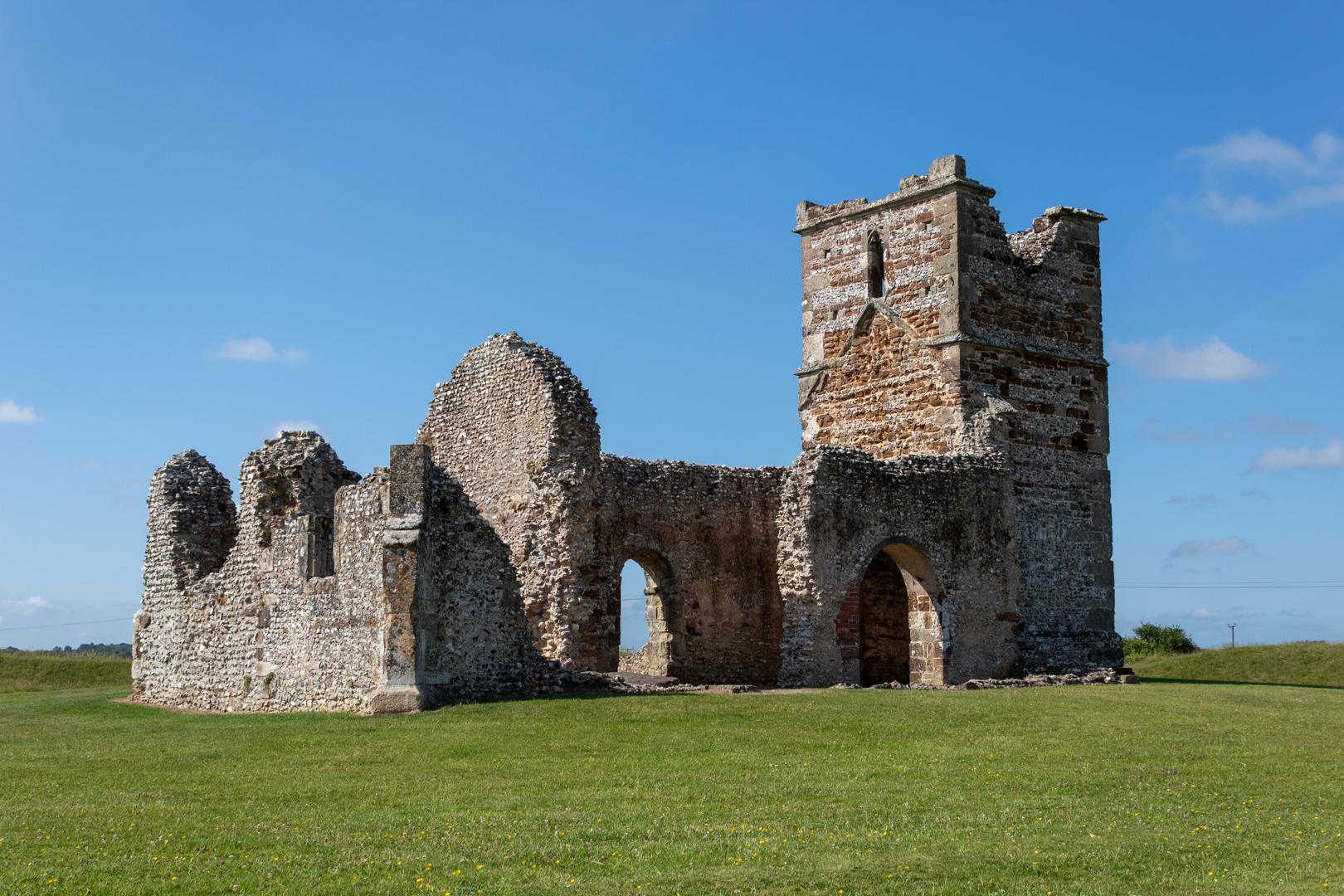
Knowlton Church


The Knowlton Church and Earthworks in Wimborne, Dorset, has a rich history that spans thousands of years. 

It encompasses both prehistoric rituals and later Christian worship, 

and is renowned for being one of the most haunted places in Dorset.


Visit Date June 2025


Knowlton Church
Knowlton Church


The site is part of the English Heritage collection of historic locations and is renowned for its Neolithic earthworks.

The Knowlton Circles are a complex of henges and earthworks, representing a significant Neolithic and Bronze Age ceremonial site in southern England. Located in the Cranborne Chase area, this site boasts a high number and diversity of prehistoric archaeological remains. 


Knowlton Church
Click on any image for lager view


There are nearly 100 henges in Britain and Ireland, typically dating from about 3000 to 2000 BC. While they are generally believed to be ceremonial sites, they likely served multiple functions and may have changed roles over time.

The wider Knowlton complex contains five large circular or subcircular monuments. Three of these are henges, characterized by having banks outside their ditches: the Southern Circle (the largest), the central or Church Henge, and the Northern Circle, which is marked by a group of ancient yew trees. 


Knowlton Church
View of henge ditch and circle.


Adjacent to these henges is a smaller monument, known as the Old Churchyard, which also features an external ditch and is likely prehistoric, despite its name. On the opposite side of the central henge lies a large, tree-covered mound called the Great Barrow. This mound is the largest barrow in Dorset and is surrounded by two concentric ditches. 
Much of this is difficult to see as it is overgrown however An aerial photograph of Knowlton earthworks seen from the north-east was taken in 1995, when the dry weather revealed more earthworks.
This can be seen on the English heritage web site.


Knowlton Church
Knowlton Church


The choice of this location for monument construction was likely significant, possibly connected to natural features such as the River Allen and dolines (sinkholes), which may have held cosmological meaning for ancient communities. Archaeological investigations by John Gale and Bournemouth University suggest that the site evolved over time, serving as both a geographical and spiritual home for communities for approximately one thousand years. It became a major focal point for funerary complexes. 

Evidence indicates the presence of a "Beaker" period structure from the second half of the 3rd millennium BC, which may have been contemporary with the Southern Circle and was later replaced by a funerary site. 


Knowlton Church
Knowlton Church - Norman Arches


The church's Norman origins are evident in the plain round arch that leads to the east end, or chancel, as well as in the round-headed arches of the arcade that separates the nave from the north aisle. The south door also exhibits Norman characteristics. At the west end, there is a 15th-century tower constructed from flint with stone bands, and the outline of the church roof is clearly visible on the eastern face of the tower.

The church was intentionally built in the heart of a former pagan site, illustrating how early Christians sought to convert the local population by repurposing existing pagan places of worship and incorporating them into their faith. Standing stones, which had been sacred for millennia, were reportedly broken apart and used in the church's construction, while others were toppled and buried. This "curious pairing" of the henge and the church symbolizes the transition from pagan to Christian worship.


Knowlton Church
Knowlton Church - Showing stone


On the northern edge of the site, it is possible to see a stone left on the ground, a possible remnant of the Neolithic site? The top of another stone can been seen alongside which is buried well below the ground.


Knowlton Church - Yew trees and tributes
Knowlton Church - Yew Trees and tributes


To the north of the church and possibly marking a northern entrance, two yew trees stand as a poignant reminder of those we cherish. People have been leaving heartfelt tributes and memorials, adorning the trees with ribbons and plaques that reflect their love and memories. It’s a touching tribute to the bonds that connect us all.


Knowlton Church
Knowlton Church


A thriving community once existed in the village of Knowlton. However, the population was decimated by the Black Death in the late 15th century, leading the few surviving inhabitants to abandon the village and migrate elsewhere. Their houses fell into decay and were eventually plowed into the earth, with only vague traces of the foundations still visible to the west of the church. Despite this decline, Knowlton Church continued to attract a congregation for several more centuries, serving as a place of worship until the 17th century, or possibly even the 18th century, when its roof collapsed, after which it was abandoned. Today, it remains a "melancholy ruin."


Knowlton Church
Knowlton Church - N/W view


Knowlton Church is well-known for its haunted history, with numerous individuals claiming to have encountered paranormal events there. A "spiritual paradox" is evident, as the attempts of early holy men to impose Christianity over pagan beliefs ultimately failed, leaving the church in ruins.


Knowlton Church
Knowlton Church - Detail


There have been many reported sightings at the ruin.

A phantom horse and rider are said to gallop across the site in the dead of night, passing straight through the church.

A ghostly face has been witnessed peering from the top window of the tower.

The shade of a weeping woman, sometimes described as a nun, has been seen kneeling outside the church.

A phantom black dog has been sighted in the area.

A mysterious cloaked man has been spotted walking around the outside of the church, sometimes in daylight hours, before vanishing. Witnesses have commented on a "truly menacing aura" emanating from him.

In the 19th century, there is a story about thieves who tried to steal a large brass bell from the church tower. However, the bell fell into a river and could not be retrieved. It is said to ring from the ruined tower on stormy nights.


Knowlton Church
Knowlton Church - Detail


 Paranormal groups investigating the site have reported experiences of being surrounded by swirling white mist and hearing ethereal voices. In November 2020, paranormal investigator Jeff Higgins and his son, Stephen, visited the church at night and recorded what they believe to be a ghost on camera. They noticed movement from the left side of the frame to the right. Additionally, they recorded exceptionally high readings on their K2 and Mel meters, which measure electromagnetic fields, with the Mel meter reaching a level of 50.8, a reading described as "unheard of." Jeff believes this could indicate an "intelligent haunting," meaning the entity is aware of its surroundings and can interact with the environment. Some locals speculate that the henge itself serves as a "ghost trap," confining spirits within the circle.


Many people have said that the atmosphere was eerie on their visit or that they felt unsettled or uncomfortable here. I have to say I did not feel any of that; it just seemed a pleasant, quiet place.


Footer:Visit Information: -
Google Reference: -
50.89215795000064, -1.9670242050628584

What Three Words reference: -
///recapture.waking.starters

OS Details: -
Grid Ref: SU 02382 10281 elevation 193ft

Additional information.
Visiting is easy and there is a lay-by at the site (50.89156612457617, -1.9682256414495787).
Access easy from here.
The site is well signposted off the B3078 in the small village.


There are no facilities at this site.


A full list of blogs can be found at my website


Read More

Harold's Stones 


Harold's Stones

In the village of Trellech, three megaliths stand. The village likely got its name from these stones, translating to either 'village of stones' or 'three stones.' The name derives from 'tri' (Welsh for three) and 'llech' (meaning flat stone).


Visit Date January 2025


Harold's Stones : Trellech


These three large standing stones in a 12-metre alignment, all three are leaning at angles but it is unlikely that this is deliberate.


Harold's Stones : Trellech


Although a relatively small village in modern times, Trellech in Monmouthshire was one of the largest towns in Wales in the 13th century.

Harold's stones are in a 12-metre alignment with a possible fourth stone being robbed away or destroyed in the late 18th century. The stones are of a conglomerate rock that's known as pudding stone. All the stones lean at different angles with the tallest being over 4 metres in height. 


Harold's Stones : Trellech


A font in the local church has a carving of the stones with the stones numbered 8, 10 and 14 which is thought to be the height of each stone at that time.


Harold's Stones : Trellech


The precise reason for the erection of the stones is unknown however, they may have been for ritual, though an astronomical use is not out of the question.
The stones create an approximate line running between the north-east and south-west at an azimuth of about 229°, likely indicating the midwinter sunset, although the possibility of the midsummer sunrise cannot be dismissed due to the imprecise alignment today due to the movement.


Harold's Stones : Trellech


The central stone of the three has been dressed to smooth its surface and bears two large cup marks on its face.


Harold's Stones : Trellech


There is much folklore associated with the stones.

The origin of the name "Harold's Stones" remains a mystery. Local legend suggests that these stones were erected to commemorate the victory of the Saxon king Harold over the Britons. However, this theory is unlikely, as the stones date back at least 2,000 years before Harold's time. Another legend claims that they mark the location where three British chieftains fell in battle against Harold. Despite being associated with Harold's victory over the Britons, the stones are much older than that.


Harold's Stones : Trellech
Click on any image for a larger version


As another story goes, Jack o'Kent, a giant, quarrelled with the Devil on Trellech Beacon, which is the hill located directly east of Trellech. The Devil challenged Jack to a throwing match. Jack threw first, but the Devil managed to throw his object a bit farther. However, Jack, probably with his eyes closed and one hand behind his back, threw just a bit farther than the Devil. In frustration, the Devil ran off.

The location of this event varies depending on who tells the story. Some versions claim that the competition took place on Sugar Loaf Mountain, while a third version cites Skirrid Fawr, also known as Holy Mountain, as the site of the contest.


Footer:Visit Information: -
Google Reference: -
51.74277538693781, -2.7265470451085365

What Three Words reference: -
///jeep.pylon.streetcar

OS Details: -
OS Grid Ref: 
SO 49927 05145 Elevation: 206 m 

Additional information.

Visiting is easy and there is a public car park close to the site (
51.74405088914131, -2.7246217913570847) There is just a short walk along the road to the site however, this has no pavement so care will be needed. The site is marked with a monument sign.


There are no facilities at the site but there is a pub in the village and also you may be lucky enough to have tea in the village hall!


A full list of blogs can be found at my website


Read More

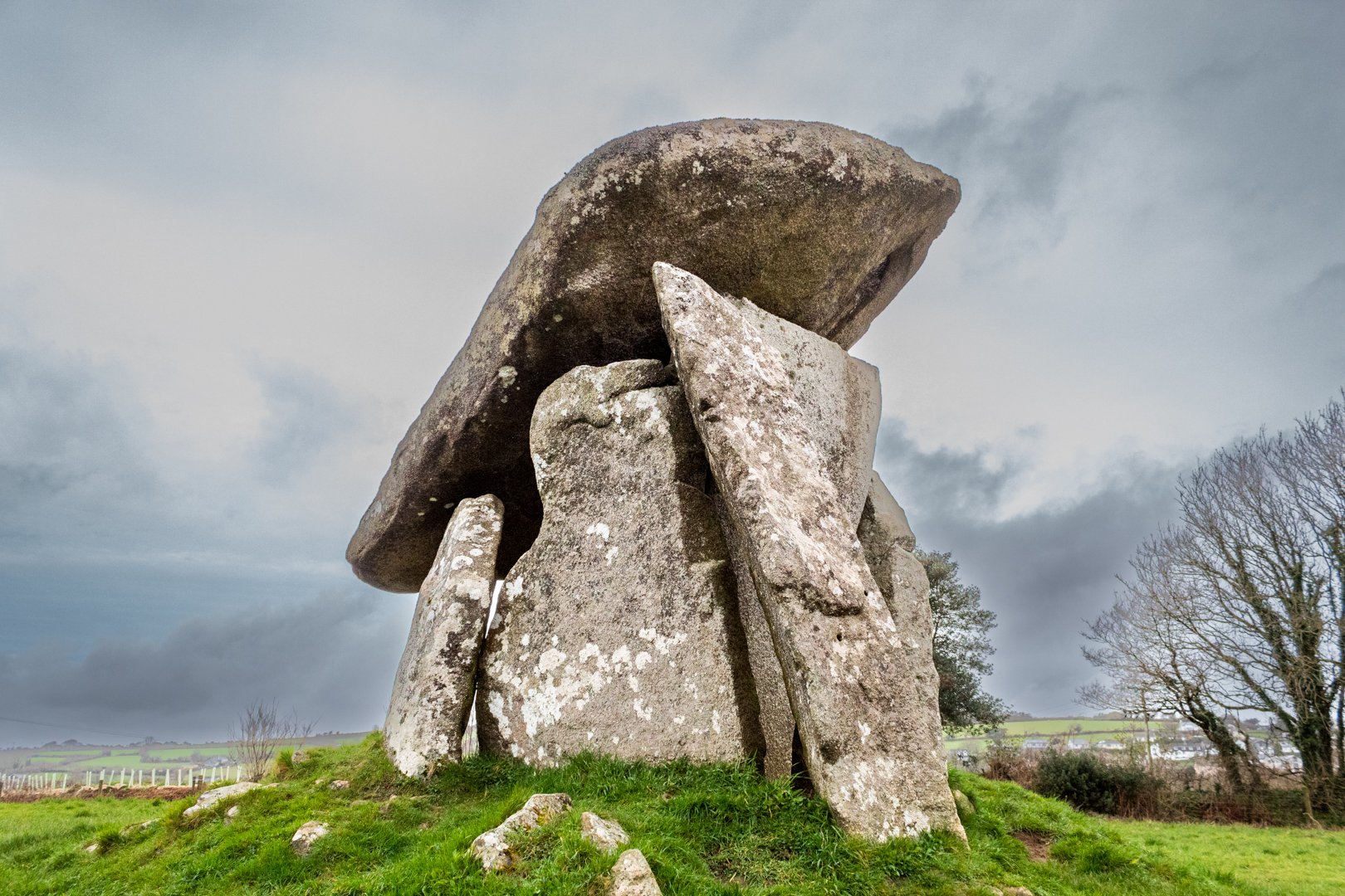
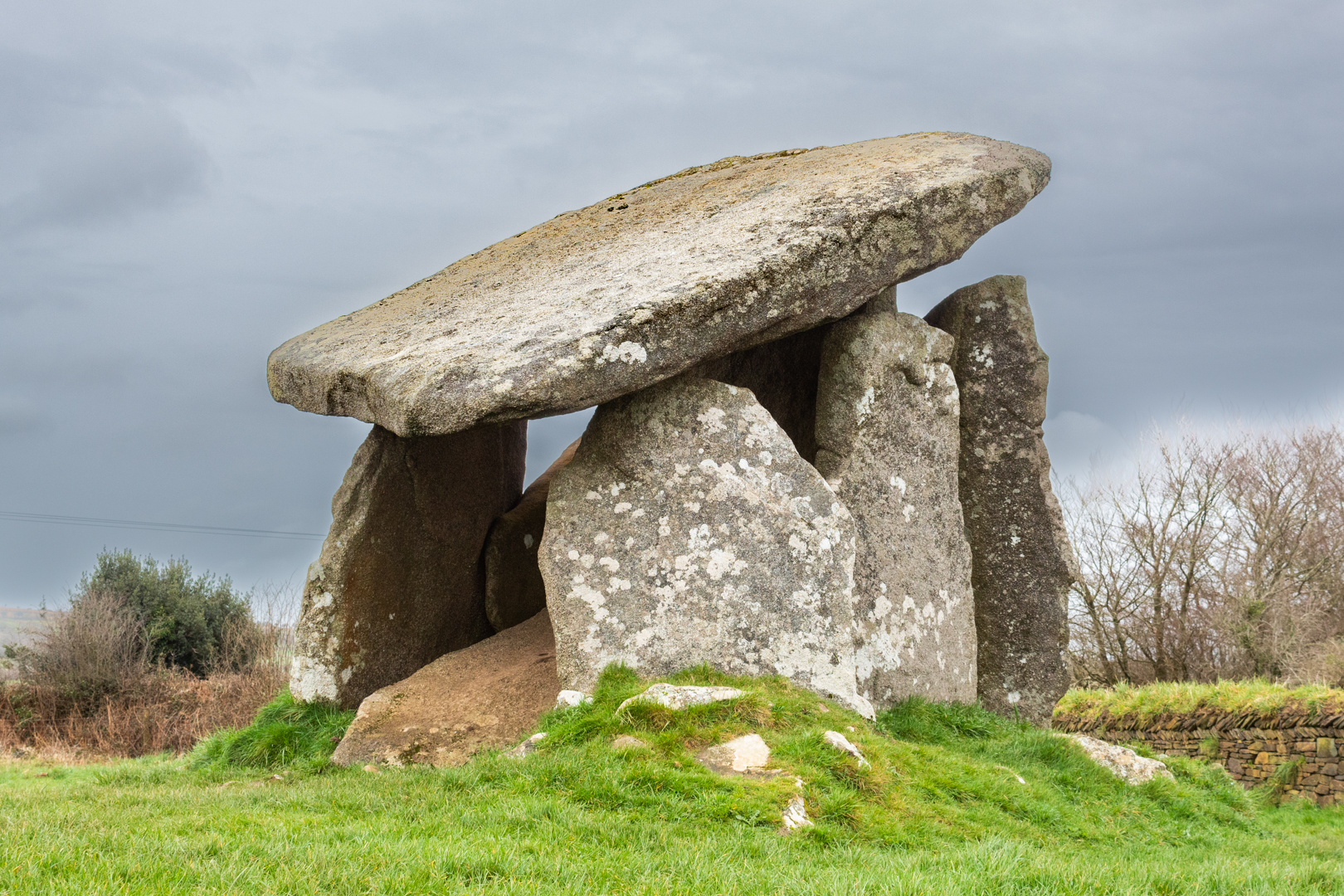
Trethevy Quoit


Known locally as "the giant's house".

Standing 9 feet (2.7 m) high, this magnificent 5000-year-old

ancient structure consists of Six standing stones capped by a large slab.


Visit Date March 2024


Trethevy Quoit
Trethevy Quoit


Walking up to this structure, it is in a field close to some modern houses you do not get a feel of the size of this structure but as you approach the magnificence of this site overwhelms you.


Trethevy Quoit
Click on any image to enlarge


There are many of these burial sites in the UK and Cornwall has a large number of them.

Like many other portal structures, Trethevy Quoit would have been originally covered by a mound.

In the 19th century, William Copeland Borlase studied the site and made drawings of it.
A later investigation of the remnants suggests a mound diameter of almost 6.5 metres.

It is impossible to tell if stones have been removed from the site but the remaining seven stones a and an estimated 10.5-ton cover slab were inside the mound.


Trethevy Quoit
Trethevy Quoit


There are some unusual aspects of Trethevy Quoit, not only does it have 6 supporting stones forming its internal chamber, but it also has an antechamber at the 'front'. The only other Cornish quoit to boast two chambers is Lanyon Quoit.


Particularly interesting is the circular hole cut in the highermost corner of the capstone. Speculation has informed us that the hole could have been used for astronomy. The movement and settling over the millennia that have passed means it is impossible to prove, but it is peculiar and thought to be unique to this megalithic site.


Trethevy Quoit
Click on any image to enlarge


The massive capstone sits at a steep angle, and this is unlikely if this was the capstone's original position. At the lower side of the capstone, five small hollows can be found.

The entrance stone at the front in most portal structures can't be moved. however, Trevethy Quoit is a rare exception here, because a small rectangular stone moving at the bottom right of the front allows access to the chamber.

There is a rectangular cut-out at the side of the upright stone that forms the front of the main chamber it is unclear if this is a later modification of if it was used and an entrance this is not seen on any other Cornish sites.


Trethevy Quoit
Trethevy Quoit


Trethevy Quoit was first mentioned in 1584 by John Norden, in a topographical and historical account of Britain.

He described it as “A little howse raised of mightie stones, standing on a little hill within a fielde”.


Trethevy Quoit
Trethevy Quoit


In Cornish mythology, the monument is known as the Giant’s House and was believed to have been created by this fabled race.
It also like many other structures in Cornwall and indeed Wales it has links with King Arthur legend and is believed to have been magically built by Merlin.


Additional information:-
A Cromlech or Dolmen is an ancient underground tomb typically built with several large upright stones and a capstone on top. In its day, the whole thing would have been covered by a mound of earth. In some parts of the UK especially in Cornwall these structures are called Quoits.
Most date from the Late Neolithic period (4000–2000 BC)


Footer:Visit Information: -
Google Reference: -
50.493185727515105, -4.455456201119047

What Three Words reference: -
///countries.extent.nibbles

OS Details: -
SX 25936 68813 : Altitude:725 ft

Additional information.

Visiting is fairly easy although the roads become just lanes for some of the way and parking is a small car park for about three cars (50.493164985542144, -4.454975466726607) and a short walk into the adjacent field.
The approach is via the B3254 and turn off towards the village of Darite. On this road you will see the turn off for the quoit.


A full list of blogs can be found at my website


Read More

The Longstone Cross (Long Tom)


Commonly known as "Long Tom" this stick of granite stands more than 2.5 metres (9 feet) high. 
Taking the form of a deliberately shaped standing stone, the top quarter is marked with a carved Greek cross. 
As is common with these early Christian crosses, it is likely to have been added to a much earlier standing stone after Christianity took hold in the area.

Visit Date March 2024


The Longstone Cross (Long Tom) Cornwall


Situated on Bodmin Moor before being inscribed with the cross, Long Tom is almost certainly part of a landscape of prehistoric landmarks.
It would seem to be aligned with the three ancient circles of the nearby "Hurlers".

Regarding the carving of the cross, it was common for the early Christians to carve crosses on existing ritual sites and for the site to have been adopted for Christian rituals.


The Longstone Cross (Long Tom) Cornwall


It is difficult often to age these stones but the carved Long Tom is thought to be at least 600 years old and possibly much older and pre-carved standing Menhir is prehistoric.


The Longstone Cross (Long Tom) Cornwall


These crosses are quite common on Bodmin Moor with at least 35 having been found and 21 of these listed as wayside crosses. Long Tom is one of the best preserved and although many of the crosses may have been moved from their original position this is not thought to be the case with Long Tom which seems to be in its original place.


The carving on these wayside crosses found in Cornwall tend to be modeled like churchyard crosses which are often made from a single stone with a rounded wheel head with a cross carving.


The Longstone Cross (Long Tom) Cornwall
The Longstone Cross (Long Tom) North Face


In Cornwall, such wayside crosses tended to be modeled after churchyard crosses or market crosses. Most were made from a single slab of stone topped by a rounded wheel head carved with religious figures. 

Wayside crosses served a dual purpose. While they were a gathering place for Christian preaching, they also served as way-markers or signposts in a landscape that could be difficult to navigate.


The Longstone Cross (Long Tom) Cornwall
The Longstone Cross (Long Tom) South Face


The cross head is decorated with an incised carving of a cross on the north and south faces. The south face is much better preserved. 


Footer:Visit Information: -

Google Reference: -
50.508796877158495, -4.461704999304393

What Three Words reference: -
///opens.assemble.bloomers

OS Details: -
SX 25546 70560 Altitude:1016 ft


Additional information.

Visiting is very easy and parking is a small lay by on the side of the road which was completely flooded on my visit.

Long Tom can easily be seen from the road on approach.

The road is much better when approaching from the south.
On the A38 you can turn off at Doublebois and head for St Cleer / Common moor and Minions. The site is around 5 miles from here.


A full list of blogs can be found at my website


Read More

Dyffryn Ardudwy Burial Chamber


Neolithic burial sites can be found all over Wales, the UK and across Europe.
I have visited many of these sites and have posted information on them here such as
What makes the site at Duffryn Ardudwy different is that there are two tombs close together.


Visit Date May 2023


Dyffryn Ardudwy Burial Chamber
Click on any image to enlarge.


The two dolmens are just 30 feet apart within a much bigger mound.

The chambers were built sometime between 4000-2000 BC, probably as a communal burial site. The entire monument was probably originally covered by a mound of small stones.


Dyffryn Ardudwy Burial Chamber
Click on any image to enlarge


The investigation following the excavation seems to explain that there had been two different periods of construction at the site.


Dyffryn Ardudwy Burial Chamber
The Western Dolmen


First, the smaller, western, dolmen had been put up and surrounded by an oval cairn.


The Eastern Dolmen
The Eastern Dolmen


Sometime later, a larger Eastern tomb was constructed with a trapezial design which was needed to combine both tombs.


Dyffryn Ardudwy Burial Chamber
Click on any image to enlarge


Today the site consists of an elongated oval, running up a slight slope, with one large chamber at the top eastern end of the slope and a smaller chamber beneath the branches of a tree at the lower western end. Beside the upper chamber is a solitary standing stone.


Dyffryn Ardudwy Burial Chamber


The site was excavated in 1961-2 by T.G.E. Powell. Although the tomb had been rifled, at the smaller dolmen a pit containing fragments of five Neolithic pottery vessels was found sealed by the cairn in front of the tomb.
This tomb has a small prehistoric cup-mark carved on one of its portal stones.


Dyffryn Ardudwy Burial Chamber
The Eastern Tomb


The second, larger megalithic tomb was built to the east and was set within a large, rectangular cairn which incorporated the earlier tomb. This later tomb produced both Neolithic and Bronze Age pottery.
Other finds included a fine, broken, stone pendant.


It was found necessary in 1961-62 to provide additional support for the great roofing stone on the eastern dolmen and a buttress was built on either side of the chamber for this purpose.


Dyffryn Ardudwy Burial Chamber
The Western Tomb


There is little doubt that the two tombs were built several generations apart.


Stones from this site have been used in the past as building materials and this is often the case at these sites but there is still a vast amount of stones around the site.


Dyffryn Ardudwy Burial Chamber


In his book, 'Guide to Ancient Britain' Bill Anderton writes that: “As part of an outbreak of light phenomena, columns of light were seen issuing from the ground here in 1905. 


The site stands on the Morchras geological fault.


Footer:Visit Information: -

Google Reference: -
52.78462455046947, -4.094379021652469

Google search term:
Dyffryn Ardudwy Burial Chamber

What Three Words reference: -
///bagpipes.genius.snowmen

OS Details: -
SH 58852 22835L : Altitude:141 ft

Additional information.

Visiting is very easy but parking close is not so.
First there is Station road parking (52.78834904037549, -4.097879713123781) this will be the closest and it is just a 500 metre walk back to the main road and down to the school where the marked path alongside the school takes you to the site.
Alternatively park opposite the community centre (52.78834904037549, -4.097879713123781) and the walk is just an additional 200 metres and you may then visit the friendly café in the community centre. Good coffee and a warm welcome.


A full list of blogs can be found at my website


Read More

Search This Blog

About Me

Bridgend, United Kingdom
A renewed interest in photography and local history.

Contact Me

Name

Email *

Message *

Followers