With a renewed enthusiasm for photography and local history, I set out this blog as a record of my experiences with images and narratives. It is my hope that you find something of interest on this site. Please feel free to contact me for more information on any of the posts. You can see a comprehensive list of my blogs at my website :- http://www.davidnurse.co.uk

Aberdulais Falls and Tin Works

Visit Date: February 2019


Aberdulais Tin Works


Aberdulais is a small village in the Vale of Neath in South Wales.

Its history starts way back in 1584, when a German engineer Ulrich Frosse, perfects a new method of smelting copper to make coins. His need was to ply his trade far from his competitors and he chose the small Welsh town of Aberdulais.

However, the story of Aberdulais really starts over 200 years later when in 1831 local businessman William Llewellyn established the Aberdulais Tinplate Company.

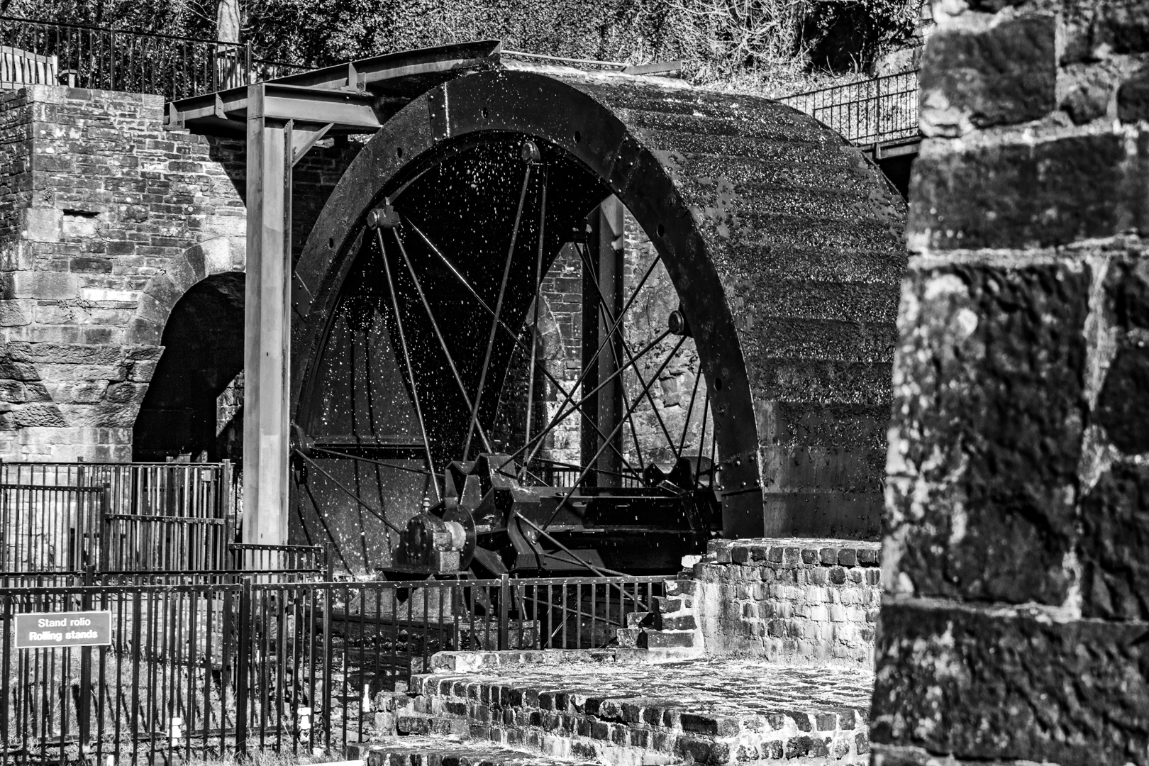
This works was one of the first to roll iron ingots into flat plates and the hammers and rollers were powered by a huge water wheel which took its momentum from the river Dulais.

Within a short space of time the Aberdulais Tinplate Company had expanded with the construction of the Lower Works, some 400 yards to the south, and the original site known as the Upper Works. The two sites were connected by a tramway. Horse-drawn drams ferried materials between them.

A further tramway was built to the wharf on the canal and then on to Swansea Docks where the tinplate was exported all over the world

Aberdulais Tin Works


A Commission report in 1842 tells us that there were 138 people working at the two sites, of whom 34 were children aged between 8 and 13.

Tinplate was so popular it was the equivalent of modern-day plastic and was used extensively as packaging for food.

However, it’s success perhaps lead eventually to the downfall of this tin works as the Americans moved to protect their own infant industry and slapped huge tariffs on tinplate imports. Aberdulais’ days were numbered.

Part of the title of this post describes the falls here are there are waterfalls that run alongside the tin works and were also used to drive the machinery.

The falls and associated industrial infrastructure are in the care of the National Trust in recognition of the site's value as a key part of the region's industrial heritage.

With so much of our history being destroyed in the past as worthless it is great to see that some of the relics of this time have survived and the visitor centre at the falls attempts to keep this history alive and thankfully has preserved the great wheel which still turns “at leisure” today.

The “falls” were unspectacular at the time I visited but one could not fail to be impressed but the reconstructed water wheel. I may revisit this after some rains to see the falls in all their glory.

Aberdulais Tin Works

Aberdulais Tin Works

Aberdulais Tin Works


Footer:

Visit Information:-

Google Reference
51.68011460292001, -3.7774655351943447

Google Search reference: Aberdulais Falls

What Three Words reference : ///descended.buns.first

Additional information

Visiting this site is easy with car parking just across the road from the main entrance.
The site is maintained by the National Trust and there is a small entrance fee. Toilets, café and gift shop are also on the site.


Read More

Mumbles Lighthouse

Visit Date: August 2020:


Mumbles Lighthouse


Mumbles is a small coastal village near the city of Swansea in South Wales.

It sits at the eastern edge of the Gower peninsular much of which forms the first area in the United Kingdom to be designated an Area of Outstanding Natural Beauty.

Mumbles or as we call it "The Mumbles" is a beautiful place to visit and I'm confident that the village will be the subject of a future blog but for now, it is the lighthouse that takes centre stage.

Mumbles Lighthouse


Built-in 1794 the tower is 17 metres high and stands on the outer of the two outlying small islands on Mumbles head between Swansea Bay and Bracelet bay.

It is 35 metres above mean high water and is one of the most photographed buildings in the area.

The Swansea Harbour Trustees were given the power to provide a lighthouse at the outer Mumbles in the Harbour Act of 1791; in July 1792 work began, but while in construction the structure collapsed in October of the same year.

In 1793 the plans of the local architect William Jernegan were accepted and the lighthouse was finally completed and lit in 1794.

Mumbles Lighthouse


Originally lit by two coal fires it was then converted to oil then a further upgrade in 1860, saw the oil-powered light upgraded to a dioptric light.

A flashing mechanism was added in 1905 and this was automated in 1934.

The lamp was electrified in 1969.

By the late 1970s the lantern was corroded and was replaced in 1987.

In 1995, the main light was replaced and an array of solar panels added.

Mumbles Lighthouse


Around the base is a fort or battery which surrounds the southern side of the lighthouse. it was built in 1860 by the War Department. It is one of the many Palmerston Forts built in response to a perceived French invasion.

It mounted five 80 pounder rifled muzzle-loading (RML) guns, two in casemates and three on the roof

In 1940 two 4.7-inch guns were manned by men of the 531st (Glamorgan) Coast Regiment, Royal Artillery. Well before the end of the war, as the German threat decreased, the battery was placed into care and maintenance.


As the lighthouse is accessible at low tide and I intend to visit the island and take more images of this landmark.

Mumbles

Very near to the lighthouse is Mumbles pier the second landmark of Mumbles.

Built and opened on the 10th of May 1898 at a cost of £10,000

During a major renovation in 2012, a new lifeboat station and Royal National Lifeboat institution gift shop was built at the end of the pier and fishing platforms added.

The original Red and cream coloured lifeboat station can be seen alongside the new station.


Footer:
Visit Information:-
Google Reference
51.566795772416825, -3.9708609642798742
Google Search reference: Mumbles Lighthouse
What Three Words reference : ///vertical.televise.junior

Additional information
Visiting Mumbles is very easy. Take the M4 motorway west until you see the first exit for Swansea then keep on the coast road through Swansea to the Mumbles.
Mumbles is a seaside town and has lots of parking along the coast and there is also a good car park on the west side at Bracelet Bay (51.566758645490815, -3.9814065526495392) which is called Limeslade bay Car Park.


Read More

Golden Hour at Ogmore Beach

Visit Date: October 2020 - (A PB Repost)

Golden Hour at Ogmore Beach


Despite all the great advice, I am not one who necessarily chases for the best light. I would say that I prefer to visit places and take the best photographs I can with what's available.

Although I love photography perhaps equally the "getting out" and enjoying the experience is what I'm after.

If a get a shot that I am happy with that's great if not? Well, there's always next time.

However last weekend the late evening light had been so good that I decided to visit one of the local beaches at "Golden Hour".

The area was very busy despite that we have not been out of lockdown very long and the number of people present made me a little uncomfortable, so the experience was not as good as I hoped, however, I thought I did get some good shots (IMHO).

I don't usually post multiple images of the same scene but in the short space of time, the scene did change.

I hope you like them.
Golden Hour at Ogmore Beach.

Golden Hour at Ogmore Beach.

Golden Hour at Ogmore Beach.

Golden Hour at Ogmore Beach.

Golden Hour at Ogmore Beach.

Footer:

Visit Information:-

Google Reference
51.45747282502195, -3.6335104586689715

Google Search reference: Ogmore beach / Ogmore-by-sea

What Three Words reference : ///spine.packages.renovated

Additional information

Visiting Ogmore beach is very easy with car parks located on the beach and along the road.
Read More

Stormy Lime Works

Visit Date: November 2021. .


Stormy Lime Works


After seeing a local report where someone had visited this site the information that he gave so interested me in this local area that I ventured out to this abandoned Lime Works and was very surprised by what I found.

The Stormy Lime works I have since heard has been also called the Pyle Lime works, the 'Stormy Stone and Brick Company' and also The Tranch Pyle Lime Works.

The coastal land of South Wales covers seams of limestone and as lime is a highly useful product in a diverse range of industries such as iron smelting, land improving and building, it is not surprising that the lime industry did well here.
There is not much officially known about this quarry but lime works or quarries along with lime kilns are scattered around South Wales and perhaps so commonplace that it was felt this smaller site was nothing out of the ordinary. I guess that would have been the case except for the condition as it stands now.

What surprised me the most about my visit was how the site had been abandoned. It was quite eerie walking around as it has something of a dystopian feel about the place. It looks as if one afternoon all the workers just up and left leaving the heavy machinery, buildings and a great hole behind just to rot.

It seems that this place was opened just after the war and carried on working until its closure in the early 1970s when as I said it was just abandoned.

There has been no effort to remove the tons of rusting machinery here or to try and fill in the void left by the quarry operation., indeed on my visit here, there were a few lads fishing in the lake that had been left by the quarry. I found it strange that this is not a river and with no inlet other than rainfall or outlet I wondered how there could be any fish in the pool however it turns out that the quarry workers stocked the pool and there are some reports of people fishing here since the closure with the common Rudd being the breed here.

Known locally as “Sammy’s pool”, but it is not clear who he is or where he lives had lived but it was the owner of the site, although there are reports that he owned a number of small sites in the area.

With over 50 years passing since the abandonment, nature and the elements have taken their toll on the site with the buildings collapsing and the metal pieces left behind rusting badly however, in the Autumn afternoon sunlight the rust almost made them appear to glow.

Of course, the site has also been visited extensively by local graffiti artists.

Please enjoy these images. (visit location information below)

Stormy Lime Works

Stormy Lime Works

Stormy Lime Works


Stormy Lime Works

Stormy Lime Works

Stormy Lime Works

Stormy Lime Works

Stormy Lime Works

Stormy Lime Works

Stormy Lime Works

Stormy Lime Works

Stormy Lime Works

Stormy Lime Works

Stormy Lime Works

Stormy Lime Works

Stormy Lime Works

Stormy Lime Works

Stormy Lime Works

Stormy Lime Works

Stormy Lime Works


Footer:

Visit Information:-

Google Reference
51.521917433606, -3.653549611707895

Google Search reference: Stormy Lime Works

What Three Words reference : ///fillings.nuns.canny

N.B I have created a short video of these images on You Tube:-


Read More

Cerrig Duon and Maen Mawr

 Visit Date October 2021.  


Maen Mawr


Another ancient site in south Wales today the site of Cerrig Duon and Maen Mawr.

The actual site is called Cerrig Duon and it consists of a very low stone circle and a standing stone just outside the circle called Maen Mawr, which unimaginatively translates to "Large Stone".

The site of Cerrig Duon (translates to black stones), which probably dates to the Bronze Age (c. 2300 - 800 BC) has also been listed as a stone row and there are two stones outside the circle leading to Maen Mawr and then onto the circle, I am not sure if I would say this was a stone row? however, looking along this line to the south it does seem to line up well with the dip between two mountains to the south and if there was a reason for this I suspect it has been lost in time. Although the circle does not protrude from the ground very much it is a stone circle or perhaps a stone oval would be more correct as it does seem slightly oval in shape.

The stones are all rough slabs of sandstone.

The Stone, Maen Mawr itself is about 7 feet high, nearly 3 feet thick, and about 4 feet wide. The site stands on a flat ridge away from the river in the valley and the views here are magnificent.

There is a theory that the Maen Mawr stone acts as the gnomon of a sundial, casting a shadow aligning with the small stones on midsummer day, I don't really buy into this theory but who knows?

Getting a little higher view makes it easier to see the circle part of this site, but I suspect the vegetation has overgrown too much as early records show as many more with Cadw (the Welsh Government's historic environment service) lists the site as having 20 Stones.


Maen Mawr
Click on images for full screen view
Maen Mawr

Maen Mawr

Maen Mawr

Maen Mawr

Cerrig Duon


Footer:

Visit Information:-

Google Reference
51.87248150044887, -3.670084955951269

Google Search reference: Maen Mawr

What Three Words reference : ///skipped.prime.punctuate

Additional information

Visiting this site is quite easy as the main stone can be spotted from the road. Going north on the A4067 the left turn is a little over a kilometre past the Dan-Yr-Ogof visitors centre and just beyond the
Tafarn-y-Garreg Pub.
Once going north it is more difficult to spot but driving south it come into site on the right hand side over the other side of the river.
There are small pull ins along the road and although you will have to cross the river this is easily done.
The circle being low to the ground can not be seen from the road.

Read More

Search This Blog

About Me

Bridgend, United Kingdom
A renewed interest in photography and local history.

Contact Me

Name

Email *

Message *

Followers